Almost every multi day cruise in the archipelago follows one of two broad directions, and the choice determines which animals a passenger will realistically see. The western route concentrates on Isabela and Fernandina, the youngest and most volcanically active islands, while the eastern and southern route covers Española, San Cristóbal, Santa Fe and the older, heavily eroded terrain at the opposite end of the chain. These are not interchangeable products with different marketing labels. They sample genuinely different ecosystems.
The separation is driven by oceanography rather than geography alone. The Cromwell Current, a deep equatorial undercurrent, strikes the western flank of Isabela and Fernandina and forces cold, nutrient dense water toward the surface. That upwelling supports penguins, flightless cormorants and feeding whales at a latitude where none of them should logically exist. The eastern islands sit outside that influence, receive warmer water and clearer visibility, and host the archipelago’s largest seabird colonies instead.
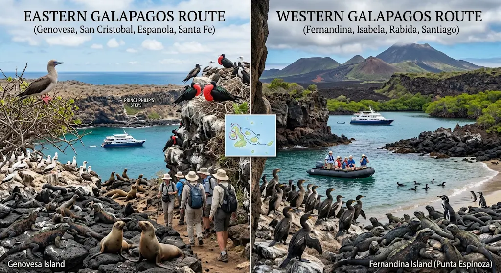
A third factor is time. Western itineraries require long overnight navigation and are therefore rarely available on short cruises, while eastern and central combinations fit comfortably into four, five or six day formats. Anyone comparing options should treat itinerary length as a filter before comparing species lists.
| Comparison Metric | Western Route | Eastern and Southern Route |
|---|---|---|
| Core islands | Isabela, Fernandina, western Santiago | Española, San Cristóbal, Santa Fe, South Plaza, Floreana |
| Typical duration | 7 to 8 days, occasionally 6 | 4 to 8 days |
| Usual embarkation | Baltra | San Cristóbal or Baltra |
| Water temperature | About 16 to 22 °C, coldest in the archipelago | About 21 to 27 °C |
| Snorkeling visibility | Often reduced by plankton, wetsuit essential | Generally clearer, more comfortable |
| Signature wildlife | Galápagos penguin, flightless cormorant, whales, mola mola | Waved albatross, Nazca and red footed boobies, sea lion colonies |
| Reptile highlights | Largest marine iguana colonies, wild giant tortoises at Urbina Bay | Santa Fe land iguana, Española marine iguana with red coloration |
| Landscape | Active shield volcanoes, recent lava fields, uplifted coastline | Eroded terrain, cliffs, white sand beaches |
| Strongest season | June to November for cetaceans and seabird feeding activity | April to December for albatross presence on Española |
| Best suited to | Repeat visitors, wildlife specialists, cold water snorkelers | First time visitors, seabird interest, shorter schedules |
Why the Western Islands Are Cold and the Eastern Islands Are Not
The Galápagos sit on a hotspot, with new crust forming in the west and drifting southeast over millions of years. Fernandina is the youngest island in the group and one of the most volcanically active places on the planet, while Española is among the oldest at roughly three to four million years. That age gradient explains almost everything else. Western islands are steep, raw and barely vegetated, with lava flows from recent decades still visible from the water. Eastern islands are worn down, ringed by beaches and covered in dry forest.
Ocean conditions follow the same axis. Upwelling along the western shelf produces exceptional biological productivity, which is why the archipelago’s marine mammals concentrate in the Bolívar Channel between Isabela and Fernandina. Bryde’s whales, common dolphins and occasionally orcas feed there, particularly during the cool season. The eastern islands lack that mechanism and instead offer warmer, clearer water that suits reef fish, rays and large sea lion colonies.
Penguins, Cormorants and the Case for Going West
Roughly 95 percent of Galápagos penguins live around Isabela and Fernandina, and the flightless cormorant exists nowhere else on Earth except those same two coastlines, with a global population measured in the low thousands. Neither species is reliably seen on an eastern itinerary. For visitors whose priority is rare endemics rather than sheer volume of animals, that single fact usually settles the decision.
Punta Espinoza on Fernandina holds the densest marine iguana aggregations anywhere, hundreds of animals stacked on black lava. Punta Vicente Roca, on the northern tip of Isabela, is a deepwater snorkeling site where green sea turtles gather in unusual numbers and the ocean sunfish occasionally appears in cold upwelling. Urbina Bay offers something no other site provides, a stretch of seafloor uplifted several meters during a 1954 volcanic event, now walked on foot with wild giant tortoises and land iguanas present seasonally.
The cost is comfort. Water is cold, seas between islands can be rough, and the navigation demands a full week. Snorkeling without a proper wetsuit is unpleasant rather than merely chilly.
Albatross Colonies and the Seabird Argument for the East
Española is the sole breeding site on the planet for the waved albatross, a species with a wingspan approaching two and a half meters. Birds arrive around late March or April and the last chicks depart by December, which means a January to March cruise will not include them under any circumstances. Punta Suárez on the same island combines albatross nesting grounds with Nazca boobies, blue footed boobies, the endemic Española mockingbird and the brightly colored marine iguana subspecies found only there. Travelers wanting a preview of the island’s terrain can compare the Española day tour format before booking a full cruise.
Eastern and northern extensions add further density. Genovesa, reached by long overnight crossing on some eastern itineraries, holds enormous red footed booby and great frigatebird colonies plus the short eared owl. Santa Fe supports its own endemic land iguana, paler and larger than the mainland archipelago species. San Cristóbal contributes Kicker Rock, where hammerheads and Galápagos sharks patrol a vertical tuff formation.
Wildlife encounters here are generally easier. Landings are gentler, swimming is warmer, and sea lion interaction is close to constant. A broader overview of what lives across the islands is covered in this guide to Galápagos wildlife species.
How the Park Rotation System Shapes Your Options
Itineraries are not designed by operators in isolation. The Galápagos National Park assigns fixed routes to each vessel and prohibits repeating the same visitor site within a 14 day cycle, which caps pressure on individual landing points. In practice this means every ship alternates between two complementary itineraries, often labelled A and B, and that a specific island appears only on specific departure dates.
Two consequences matter for planning. First, combining Fernandina and Española in one week is effectively impossible on a naturalist cruise, since the two sit at opposite ends of the archipelago. Second, short cruises of four or five days are almost always central and eastern, because western navigation consumes too much sailing time. Budget considerations are addressed separately in this breakdown of naturalist cruise pricing, and the full fleet is listed under naturalist cruise options.
Where Diving Itineraries Depart From Both Patterns
Dive liveaboards operate on a separate logic entirely. Rather than choosing east or west, they head north to Darwin and Wolf, two isolated seamounts closed to land visitors and reachable only with a specific park permit. Those routes prioritize pelagic species, particularly scalloped hammerheads and seasonal whale sharks, and the details are covered in this guide to diving Darwin and Wolf.
Most dive itineraries also include western sites on the return leg, since Cabo Douglas and Punta Vicente Roca deliver marine iguanas feeding underwater and mola mola encounters that no eastern site can match. Vessels such as the Galápagos Aggressor III and the Calipso follow that structure. Divers unsure whether a full liveaboard is necessary can review the comparison of liveaboard versus day diving.
Rules, Guides and Physical Demands on Both Routes
Regulations are identical regardless of direction. A certified naturalist guide accompanies every landing, groups are capped at 16 passengers per guide, and visitors must remain on marked trails. Minimum distance from wildlife is two meters, feeding and touching are prohibited, and all organic material must stay off the boats to prevent species transfer between islands.
Physical demands differ modestly. Western landings involve more uneven lava terrain and a higher proportion of wet landings from pangas, while eastern sites include long beach walks and some steep stairways, notably at Genovesa. Sturdy closed footwear, sun protection and a dry bag are required on both. A 3 to 5 mm wetsuit is genuinely necessary in the west and optional in the east.
Reading the Archipelago as Two Different Systems
The east versus west comparison is ultimately a question about what a visitor wants to understand rather than simply what they want to photograph. The western islands demonstrate the archipelago as an ongoing geological process, with colonization still underway on surfaces younger than most human infrastructure. The eastern islands show the later stages of the same sequence, where erosion, soil formation and long isolation have produced highly specialized endemics confined to single islands.
Neither half offers a superior wildlife experience in absolute terms. The west concentrates rarity, holding species with global populations small enough to be counted individually. The east concentrates abundance and accessibility, with breeding colonies numbering in the tens of thousands and conditions that suit visitors of any fitness level. A statistical comparison of species counts would favor the east, while a comparison weighted by conservation significance would favor the west.
What both routes share is the constraint that makes them viable. Fixed itineraries, capped group sizes and rotation between sites keep visitation distributed across dozens of landing points instead of concentrating it on a handful. That system, more than any individual regulation, explains why wildlife in the archipelago continues to behave as though humans are a neutral presence. Choosing a route is therefore less about maximizing sightings and more about deciding which portion of a single evolutionary sequence to observe closely.
Frequently Asked Questions About Eastern and Western Galapagos Cruises
Can one cruise cover both the eastern and western islands?
Not on a standard seven or eight day naturalist itinerary. Fernandina and Española sit at opposite ends of the archipelago, and park assigned routes do not combine them. Visitors wanting both typically book back to back cruises or add a land based extension between departures.
Which route is better for seeing Galapagos penguins?
The western route, clearly. The overwhelming majority of the population lives around Isabela and Fernandina, with small numbers at Bartolomé and Floreana on central itineraries. Penguin activity increases during the cool season when upwelling strengthens and food availability rises along the western coastlines.
When are waved albatross present on Española?
Birds occupy Punta Suárez from roughly April through December, with courtship displays concentrated in the middle of that window and fledging toward the end. From January to March the colony is empty because the entire population disperses to feed at sea off the coasts of Peru and Ecuador.
Is the western route too rough for most travelers?
Seas between Isabela and Fernandina can be choppy, particularly from June to November, and navigation legs are longer than on eastern routes. Larger vessels handle this better than small yachts. Passengers prone to motion sickness should start medication before departure rather than after symptoms begin.
Which route offers better snorkeling?
The east and central islands offer warmer water and clearer visibility, making them more comfortable overall. The west delivers higher biomass encounters including sunfish, penguins and feeding marine iguanas, though water can drop toward 16 °C and plankton frequently reduces visibility.
Do short cruises visit the western islands?
Rarely. Four and five day itineraries concentrate on central and eastern sites because the sailing distance west consumes too much of the schedule. Reaching Fernandina and northern Isabela realistically requires a seven or eight day departure with two full nights of navigation built in.